
By Pam Martens and Russ Martens: October 1, 2024 ~
If you think you are safe from climate change, sea level rise, Category 4 and 5 hurricanes, storm surge and the like because you don’t live near an ocean or the Gulf of Mexico, the humanitarian crisis from Hurricane Helene that is playing out in Western North Carolina should quickly reorient your thinking on the matter. (You can be assured that it is doing just that in actuarial offices at insurance companies across the United States right now.)
The worst hit areas of Western North Carolina – cities and towns like Asheville, Chimney Rock, Lake Lure, Fairview, Black Mountain, and Swannanoa – are 485 miles north of Perry, Florida, the town closest to where Hurricane Helene made landfall on Thursday night, September 26, as a Category 4 hurricane on the coastline of the Gulf of Mexico. These decimated towns in Western North Carolina are also hundreds of miles from the Atlantic Ocean coastline. But none of that prevented apocalyptic flooding from Hurricane Helene to reduce much of these towns to rubble, leaving citizens without electricity, running water, cell phone service, or the necessities of life like food and sanitary water. For those that survived, this is the fifth day of this dystopian hell.
Most Americans are rightly confused as to how a Category 4 hurricane could sustain this type of wallop after traveling 485 miles to northern inland country over rugged terrain. The main problem for Western North Carolina wasn’t wind speed – but over two feet of rainfall in some areas over three days that transformed scenic rivers into raging beasts that wiped out homes, entire towns, roads, bridges, water mains and left some electric utility substations submerged under water according to Duke Energy, which supplies electricity to much of the area.
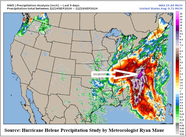
Meteorologist Ryan Maue (who has been a climate change skeptic in the past) posted the above graph on his Twitter (X) page on Sunday, indicating that between Tuesday, September 24, and Sunday, September 29, there had been 20 trillion gallons of rainfall across Florida, Georgia, South Carolina, North Carolina and Tennessee. We’ve added the white arrow to his chart above, pointing out the pinkish area where over two feet of rain fell in Western North Carolina.
Maue may be underestimating what happened in Western North Carolina, however. His graph shows a maximum 5-day rainfall over the Hurricane Helene impacted area of 25.84 inches. A Weather Station in Busick, North Carolina, however, recorded a 3-day rain total of 31.33 inches.
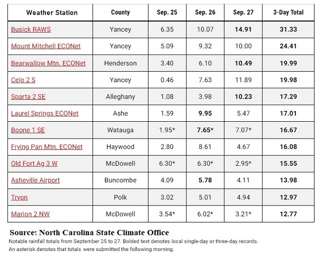
The North Carolina State Climate Office posted the chart below, showing record-setting 3-day rainfall totals at 12 Weather Stations in Western North Carolina. According to the Busick, North Carolina Weather Station, as of 8:00 a.m. this morning, Busick has had 79.02 inches of rain year-to-date – but an unfathomable 31.33 inches of that rain came in the three-day period of September 25-27 during Hurricane Helene. That means 40 percent of the rainfall year-to-date in Busick arrived over 72 hours. Equally frightening, as the graph below shows, a record-setting 14.91 inches of rain fell in just one day, Friday, September 27 – the day that rivers raged over their banks and erased multiple towns and dozens of human lives in Western North Carolina. (As of this morning, the state of North Carolina is reporting a total of 56 confirmed deaths from the hurricane with more than 600 persons still missing.)
According to NOAA Senior Scientist Tom Knutson, the most recent assessment report by the Intergovernmental Panel on Climate Change (IPCC) has concluded the following:
Hurricane “rainfall rates are projected to increase in the future due to anthropogenic warming and accompanying increase in atmospheric moisture content.” Anthropogenic warming means that as greenhouse gas emissions increase, they trap the sun’s heat. This leads to global warming and climate change. The planet is now warming faster than at any point in recorded history. Hurricane Helene drew its energy from the Gulf of Mexico, whose waters hit record hot temperatures in August, registering surface temperatures of 90 degrees. At one point before landfall, Hurricane Helene was 430 miles wide — packing enormous amounts of hot moisture to sustain its own energy as it moved hundreds of miles inland.
The IPCC assessment also concludes that hurricane intensities globally are projected to increase. “Rapid intensification is also projected to increase.” Hurricane Helene went from a Category 1 to a Category 4 in less than 24 hours as it fed on the record hot waters of the Gulf of Mexico.
For what you can do to cut back on energy usage to help reduce global warming, see our report here.